From unsafe arterial to thriving main street

[ad_1]
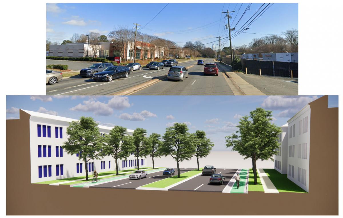
Currently, West Boulevard in Charlotte is anything but a safe and comfortable walk. A narrow sidewalk directly abuts travel lanes where traffic goes 50 miles per hour. There are no street trees or parked cars to buffer pedestrians. Those on foot sense constant danger.
The alternative vision is a safe and walkable destination—an “urban main street”—according to Murphy Antoine, principal with Torti Gallas + Partners, urban designers in a CNU Legacy Project, cosponsored by the West Boulevard Neighborhood Coalition (WBNC). “The idea of taming West Boulevard is important—it’s not just for cars to zip from Uptown to the airport,” he insists. “West Boulevard could be a place to visit, not just to drive through.”
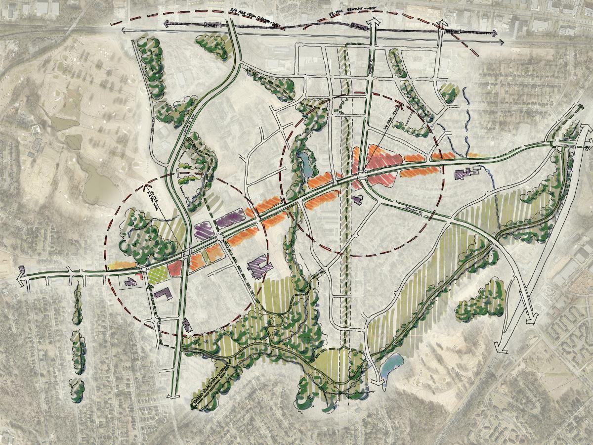
Legacy Projects are annual design and implementation events that apply CNU’s placemaking expertise to make a difference in the Congress’s host region, in this case Charlotte. The West Boulevard study area stretches two miles, including two important mixed-use intersections at Clanton and Remount roads. Home to many African American families, the corridor has long lacked investment yet now faces growing development pressures from the east and north.

Of three Legacy Projects that CNU organized in advance of CNU 31, West Boulevard relates most directly with this year’s Congress theme of “corridors.” A corridor may take many forms—a transit line, a multiuse trail, a waterway—but in this case, West Boulevard is a four-lane suburban arterial road that carries fast-moving traffic through neighborhoods west of Interstate 77 on the west side of Charlotte.
That context could be greatly improved with the right policies, explains Mallory Baches, president of CNU. “The complex condition of the Corridor can serve as a powerful urban problem-solver,” she says. “Still, their successful design must embed the broader principles of walkable, sustainable, equity-supportive urbanism that we practice as New Urbanists.”
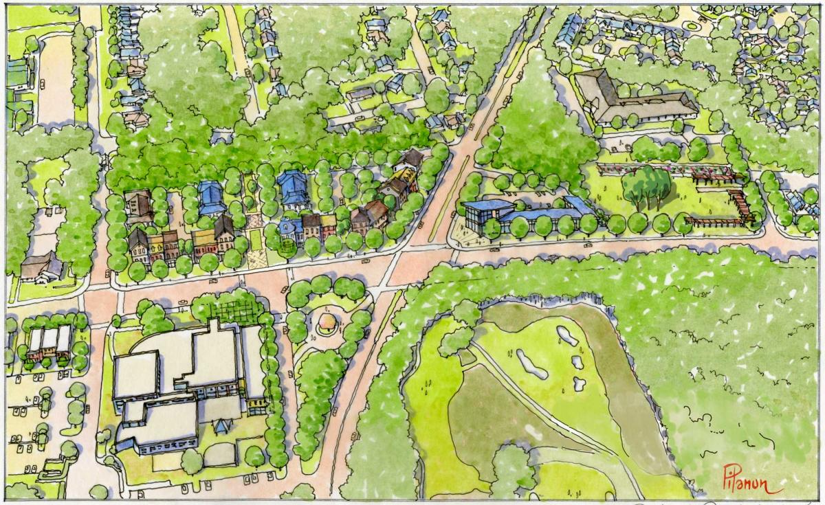
Torti Gallas worked with WBNC and CNU on a community charrette to identify implementation and improvement strategies. The Clanton Road intersection, where a YMCA is planning an expansion, has great potential to be the civic heart of the neighborhood. The crossroads is currently configured for high-speed traffic. The team redesigned it to “promote safety and community focus.” They planned a public space with dimensions that would make crossing easier. A variety of buildings around the intersection could form the walls of an outdoor room.

The community owned Three Sisters Coop Market is also planned at the intersection, and the business is considered a catalyst for the corridor. The market would be the community’s first grocery store in 40 years, and it is moving forward now after years of futility. “We’ve had community efforts for four decades to get a grocery store,” says Rickey Hall, board chair of WBNC, which is taking the lead on the project. The organization owns a site that is already being used as an urban farm and outdoor market, and the physical building could be transformational. The federal government has pledged $750,000 to cover soft costs for the project. A major real estate developer, Crosland Southeast, is consulting on project management. The organization interviewed general contractors soon after the charrette. The plan is to build a physical building (store), then turn over control to the Food Coop Market Board to operate under leadership of a professional general manager.
Adjacent to the store, a public space is planned that already includes three mature shade trees, symbolic of the Three Sisters name—referring to Native American and African companion planting techniques, Hall explains. The plan also proposes planting three saplings in the green space, to take the place of the mature trees when they die, probably decades hence. The two tree trios symbolize sustainability long into the future. The green space would be a designed for community events like an outdoor market. In addition, space is being studied for aquaculture, food production, and education for healthy eating, to boost nutrition and food security for the community. “This is intended to be more than just grocery store,” Hall says. “We are building on a model that seeds the community with economic development and builds wealth—not just a service model.”
The area around the intersection is also planned for several blocks of context-sensitive infill that respects existing neighbors, including housing and other uses. The Y is engaged in the Legacy Project and the plan looks at how the expanded YMCA could help to shape the intersection. Several neighborhoods surround the intersection, including the Arbor Glen community, were built as a HOPE VI public housing redevelopment (in the 1990s, CNU influenced the urban design related to that federal program).
The Remount Road intersection, the other major node along the corridor, was reported to have significant crime and public safety issues, centered around vacant commercial properties. Most of the neighborhood weaknesses and threats were identified in this area. More mixed-use development is envisioned at Remount Road because, “increased commercial and residential presence can help reduce unwanted behaviors,” according to the design team. The intersection is envisioned as a “commercial and employment focused node.”
At the heart of the West Boulevard plan is Torti Gallas’s concept of “addification,” a response to gentrification. With gentrification, new residents come and overtake the neighborhood. Addification is designed to build opportunities, but make sure they are available for everybody. The plan would add housing, healthy foods, health care services, transportation options, and economic opportunity (residents can participate in the building of wealth).
Addification “tries to harness some of the positive aspects of gentrification, without displacing the folks who have been here for generations,” Antoine explains. Respecting businesses and shop-owners that have invested in the community is paramount. A goal would be to make sure local businesses can make changes to their buildings under proposed zoning rules.

Charrette participants articulated seven overarching goals for West Boulevard:
- Preserve the history and legacy of the community.
- Provide support for residents that want to stay in the area. Help build generational wealth—maintain ownership for future generations.
- Provide a tax break for long term homeowners.
- Prevent existing local businesses from being pushed out of the community.
- Help establish incubator businesses to support local entrepreneurs.
- Support a mix of uses at the intersections of West Boulevard and Clanton Road and West Boulevard and Remount Road—Provide easy access to education, job training, and job opportunities.
- Provide easy access to health care and healthy foods.
In addition to development work on the market, a number of projects are scheduled for near-term implementation. An artist designed placemaking markers to highlight underrepresented people and events in the neighborhood history. That project, presented at the charrette, is expected to take about a year. Also in the short-term bucket are tree plantings and promoting policies aimed at tax breaks for long-term residents who are seeing their bills go up now that values are rising. Mid-term plans include a new health care facility and implementation of traffic calming at key nodes. In order for effective traffic calming to take place, the City likely will need to take ownership from the state DOT, the planners believe. That change already happened a mile away, where West Boulevard turns into East Boulevard. The need for this ownership transfer was raised in discussions with the City after the charrette.
West Boulevard has been identified by the City as a key corridor for changes that benefit neighborhoods that have long been bypassed by investment. “With its Corridors of Opportunity program, the city is investing $38.5 million to address the interrelated city-building challenges of housing equity, economic development, community safety, available mobility, access to nature, and local identity—all of which tie to successful corridor design,” Baches writes.
As the Charter of the New Urbanism explains, the contemporary metropolis must accommodate automobiles, but do so in ways that respect the pedestrian and the form of public space. West Boulevard is a thoroughfare that should handle cars, but also serve as an urban main street for a community.
[ad_2]
Source link
